The earliest dedicated aviation specific navigation aid was developed in the 1920’s and was called Four Course Radio Range or otherwise known as the A/N radio range. By transmitting low to medium frequency, (LF/MF) directional radio signals the pilots could home electronically to the station without the need of a visual fix.
Electronic position estimation started its life here in aviation. A/N radio range was the ‘grandfather’ of the Non Directional Beacon (NDB).
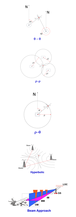
Today, several techniques exist to allow the flight crew and/or the avionics to derive an estimated position electronically and in some cases provide guidance to the aircraft. These can be summarised as follows:
Angular
A position can be derived using angular information transmitted from a pair of stations with known locations. This would be described as an azimuth technique (sometimes documented as Q-Q ). The position line is determined by receiving and processing a beam transmission or by radio direction finding.
This technique give the relative azimuth of the aircraft with respect to the transmitting station. To obtain positioning, knowledge of relative azimuths to two stations is required.
VHF Omni-directional Range (VOR) or Non Directional Beacon (NDB) are two NAVAIDs that enable an angular position to be dervied.
Ranging
Ranging techniques (sometimes documented as r-r) where the distance from a transmitting station is calculated. These techniques are based on measuring the transit time of an electromagnetic wave, which is emitted by a primary radiator. The focus of the points equidistant to a fixed one is a circumference, and so three measurements (relative to three stations) are required.
Distance Measuring Equipment (DME) and GPS apply this technique; however, in GPS’s case the stations are constantly moving.
Range and Bearing
The combination of the Q and r techniques described above are called r-Q techniques, with that combination we can obtain positioning.
RADAR and a combined VOR/DME station use this technique.
Hyperbolic
The basic principle is that two stations transmit signals synchronously. Positions of equal transit time differences result in hyperbolic position lines. A third transmitter brings up a further hyperbolic field, enabling position determination.Hyperbolic positioning is not used in aviation today.
Long Range Navigation (LORAN) applies this technique as did the obsolete OMEGA and DECCA systems
Beam Approach Techniques
Different directed signals are used in order to guide an approaching aircraft towards a fixed location, such as a runway. The beams are positioned in such a way that accurate guidance to a point can be achieved.
Instrument Landing System (ILS) uses fixed beams to guide the aircraft to a Decision Height/Decision Altitude (DA/DH) where the pilot takes over visually.