Whilst pilots probably give little thought to route design and the proximity of other routes, the place and configuration of routes is central to the job of airspace planners who use PBN-enabled flexibility to optimise route-interaction in such a way as to minimise conflict and maximise efficiency.
Particularly in the en route or extended terminal airspace, extensive route systems exist and a perennial question remains: how close can any two routes can be placed? For decades, this question conjured up visions of parallel routes and how closely they could be placed. In the last fifteen years, the question has come to relate to crossing tracks, near parallel tracks, parallel tracks, and routes interacting in multiple dimensions.
Generally, there are two methods to assess how safe the planned operation is:
- A relative method where operational personnel use their professional judgement to compare two relatively similar systems against each other and assess whether the planned future system is at least as safe as current operations.
- A quantative method where a Target Level of Safety (TLS) is identified as an absolute threshold and a mathematical assessment using collision risk modelling (CRM) is used to demonstrate that this target can be achieved.
Collision risk modelling used for the absolute method includes an assessment of risk and identification of viable mitigations. A collision risk model will include the Navigation performance, Exposure to Risk and the ability for ATC to intervene to stop a collision through Intervention.
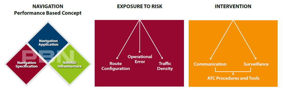
Collision risk modelling is based on a series of assumptions in all three areas:
- Navigation – In PBN this is described in the Navigation Specification in terms of accuracy, integrity and continuity together with other functionalities needed to achieve the required performance.
- Exposure to Risk – Identifies the errors that could cause two aircraft to collide. For route configuration it is how the routes are designed – parallel or intersecting, are the aircraft flying in the same direction or opposite direction on parallel routes and are the aircraft climbing, descending or in level flight? The traffic density and the occupancy on the routes will influence the probability of two aircraft in the same piece of airspace at the same time. In addition to the technical collision risk, there are potential risks from human error such as the pilot selecting the wrong route or an incorrect waypoint along an assigned route.
- Intervention – identifies how ATC can prevent a collision using communications and surveillance (if available) together with ATC support tools and defined ATC procedures.
These assumptions may be subdivided into technical assumptions on how the system works, which can be characterised through a set of numerical values, and demonstrated through certification processes. The operational errors are more difficult to quantify and the use of observed data can support these assumptions.
Two key assumptions used in European CRM are the aircraft navigation performance and ATC intervention.
- Observed aircraft navigation performance data rather than required performance is used. This can be expensive as a sizeable quantity of data needs to be collected and analysed. In addition, aircraft meeting only the required 95% performance might legitimately fly in the airspace.
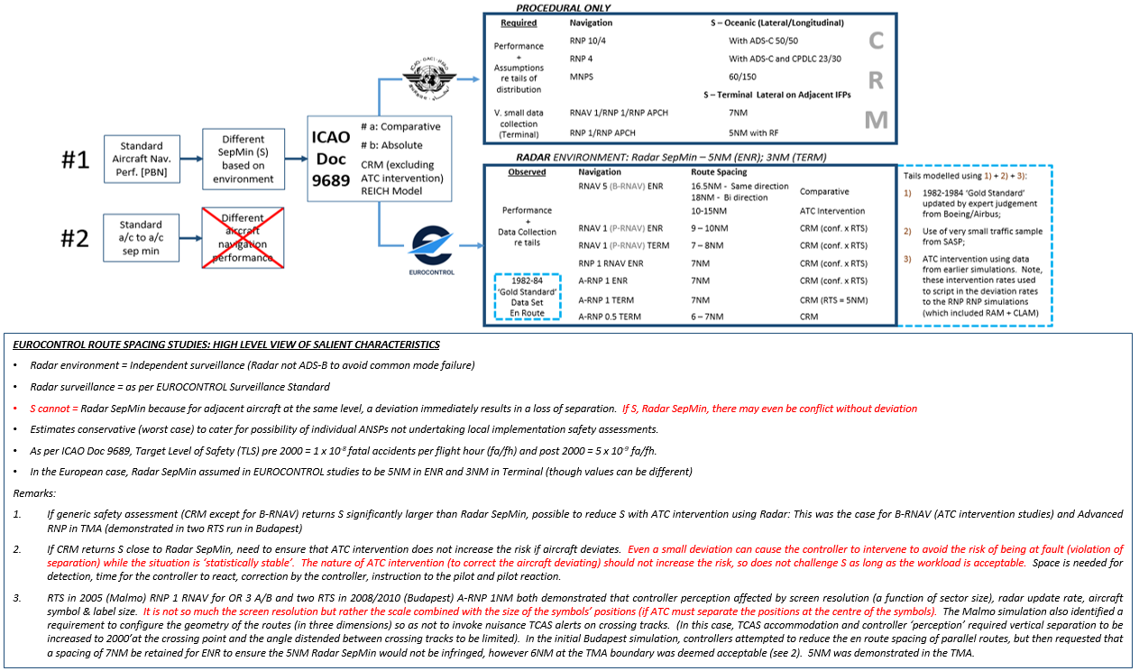
- Global separation standards and route spacing studies are normal developed considering the lowest level of ATC capability. Therefore, this is usually a procedural environment. Within Europe, we factor in ATC intervention using RADAR surveillance; furthermore, rather than using a theoretical approach to controller intervention modelling, EUROCONTROL CRM studies use controller intervention failure probabilities based on and validated by real-time simulations.
Typically, the following characteristics have been included in the European operating environment when determining route spacing:
- Actual vs. required navigation performance (prescribed in the Navigation Specification);
- Conservative traffic density (tending to worst case);
- Radar coverage with monitoring continuity (use of ADS-B surveillance will influence the CRM with a wider route spacing to meet the TLS as GNSS is a common point of failure);
- Dual radio with backup frequency;En-route operations with an radar separation minimum of 5 NM, RNAV 5 with fly-by turns limited to 20 degrees based on extensive availability of VOR and DME;
- Terminal airspace operations with a radar separation minimum of 3 NM of RNAV 1, with fly-by turns and an available infrastructure of GPS and/or DME/DME;
- All route spacing scenarios assumed the aircraft to be in the same ATC sector (the responsibility of one controller);
- All earlier RNAV route spacing studies in ECAC considered only straight parallel tracks with a need to increase the spacing between the tracks on the turns. In contrast, previous RNP studies included turning segments with constant radius turns (requiring FRT or RF capability) enabling the ability to maintain the same spacing between routes on the turn.
The table below lists the European generic route spacing studies previously undertaken to support RNAV 5 (B-RNAV) and RNAV 1 (P-RNAV) and A-RNP operations.
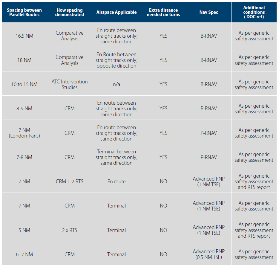
Collision risk modelling is based on assumptions concerning the specific operational environment and is fed by location-dependent data. Therefore, the output does not necessarily have universal application. Generally, the use of generic or conservative assumptions will lead to generic or conservative spacing values. However, the more specific the assumptions used in the model, the more specific the calculated spacing values are expected to be.
Therefore, the 2015/2016 European route spacing study of proximate flight procedures in terminal and extended terminal areas stresses three key assumptions, which must be understood before reading the table of route spacings tabulated in the 'European PBN Route Spacing Handbook' (PBN Handbook No. 3).

KEY POINT 1: A limitation of using Radar Surveillance as a mitigation of risk is that the spacing between two routes cannot be the same or less than the Radar Separation Minima (thus if the Radar Separation Minima is 3 NM, the spacing between routes cannot be 3NM or less). This is because a lateral deviation could instantly cause a separation infringement. As such, allowing for sufficient time for the controller to detect and correct a deviation and for the pilot to respond correctly has tended to convert into at least a minimum of 4-5 NM route spacing in an environment using 3NM Radar separation minima.
KEY POINT 2: Any published table showing route spacing values determined by particular studies must be seen in this light. No published spacing results for continental application (or study supporting these results) can be considered universal norms. Results are valid only for the assumptions and data used, the particular operating environment and airspace and operational concept envisaged. One key assumption is that aircraft being separated on closely spaced routes are within the same ATC sector. It is also stressed that route spacing values supported by extensive data, statistical analysis, mathematical modelling and airspace design do not ensure that the aircraft will adhere to the route to ensure that the route spacing is maintained. Essential to successful flight operations are proper procedure design, the correct coding of procedures in the aircraft databases and validation of the procedure to check flyability.
KEY POINT 3: the resolution of the Radar display (a function of ATC sector size) has very clearly become a determining human factor which forms part of the post-CRM implementation safety analysis to determine the acceptable (final) route spacing. To be included in these considerations are items such as label size and algorithm affecting label orientation both of which affect the potential for label overlap, as well as the aircraft ‘target’ size and so forth.
The European PBN Route Spacing Handbook (PBN Handbook No. 3) addresses the spacing of proximate flight procedures; it specifically focuses on terminal and extended terminal areas in European Radar surveillance environments. The driver for this document stems from regulatory requirements to implement PBN SIDs/STARs within the EU. A particular aspect of this implementation is the route spacing between SID and STAR procedures that can be achieved in congested airspace with radar surveillance.
The sample spacing distances derived using the ICAO/EUROCONTROL Collision Risk Model, which are based on data samples from three major European terminal areas, are published in Annex 1. However, the spacing examples could suggest that navigation performance is not the prevalent factor in route spacing determination today. The limiting factors in drawing routes closer together include the Radar separation minima of respectively 3 and 5 NM in terminal and en route operations as well as human factors such as the controller’s screen resolution and ATC sector size. Furthermore, the examples given also indicate that aspects like route configuration, procedure complexity and flyability have an important effect on achievable route spacing minima.
The European PBN Route Spacing Handbook (PBN Handbook No. 3) shows sample route spacings, it must be understood that these sample spacings are linked to particular spacing methodologies using particular traffic samples. Therefore, their inclusion in the handbook does not mean that these sample distances are automatically ready-made for implementation. A local implementation safety case must determine the relevance of the Handbook’s examples to the intended terminal area of application. Furthermore, post implementation lateral navigation performance monitoring would need to confirm the achieved navigation performance.
To download the PBN Route Spacing Handbook Edition 1 (PBN Handbook 3) click here.