There are four ‘core’ constellations:
- The United States NAVSTAR Global Positioning System (GPS) – fully operational since 1995.
- The Russian Globalnaya Navigatsionnaya Sputnikovaya Sistema (GLONASS) system - operational.
- The European Galileo system – Interface Control Document (ICD) published, awaiting ICAO SARPs and full operational declaration.
- The Chinese Beidou system – fully deployed, ICD published and awaiting ICAO SARPs.
Each system is covered in a little more depth below.
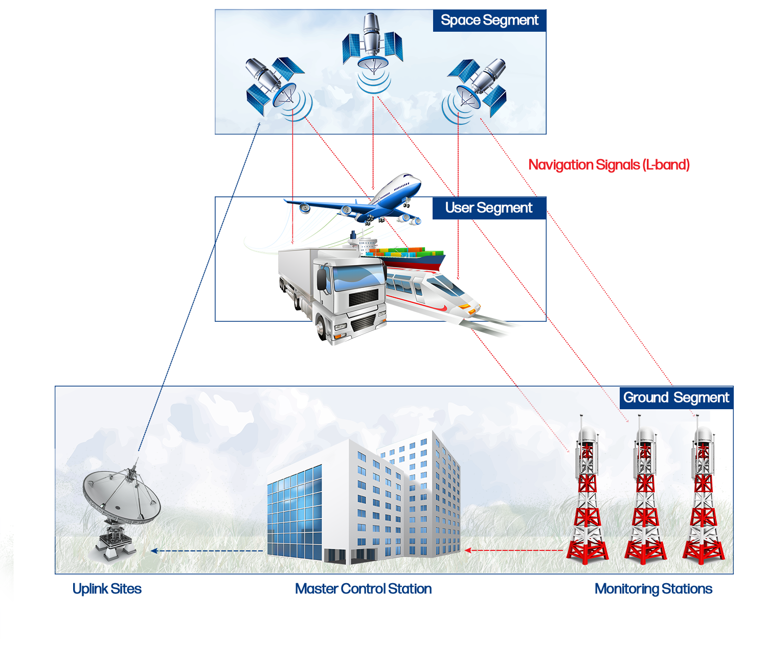
The basic components of any of these 'core' satellite constellation are as follows:
- The Space Segment. This component of the constellation consists of the elements, which are placed into space and may consist of both orbiting and geostationary satellites.
- The Ground Segment. This segment consists of all Earth-bound system components, which will include monitoring stations, control stations and uplink stations as well as the infrastructure to pass the information between those elements.
- The User Segment. This segment is not normally under the control of the constellation but is the receiver the individual user decides to buy. However, receivers are built by the manufacturers in accordance with published Interface Control documentation.
The PBN manual currently only considers IFR certified GPS receivers in each Navigation Specification. This is expected to be rectified with the publication of the fifth edition of the manual.
The NAVSTAR Global Positioning System (commonly referred to as GPS) started its development in 1973 and was declared fully operational in 1995.
The constellation transmits a navigation signal on two frequencies L1 (centred on 1575.42 MHz) and L2 (centred on 1227.60 MHz). The navigation signal on L2 was originally dedicated solely for military use and required a military grade receiver to read the information. Today, there is information that a two frequency civil receiver can read, however, as the L2 frequency is not in the aeronautically protected band, this frequency is not considered for use by civil aviation.
The latest generation satellites, GPS Block II-F and GPS III, carry a third frequency, L5 (centred on 1176.45 MHz) which is in the aeronautically protected band but will not reach Full Operational capability (FOC) until approximately 2023.
Because of the delay to the FOC of L5 and the expected availability of dual frequency, IFR certified receivers on-board civil aircraft, for the next decade civil aviation will be operating on a single frequency L1. The use of this single frequency for satellite navigation has been a concern for many years as there has always been a danger that the signal could be lost due to either interference, either unintentional or by jamming, or the impact of space weather.
When President Reagan elected to provide civilian users access to GPS L1 in 1983, following the shooting down of Korean Airlines KAL007, the military wanted to ensure that a civilian user would not have the same level of accuracy as military users. Therefore, the military introduced a deliberate degradation on the L1 frequency called 'Selective Availability' (SA). This degradation was created by a jittering of the atomic clock on-board the satellite and a slight corruption of the navigation message transmitted from the satellite. A military user with a two frequency receiver could correct for this degradation in performance whilst a civilian position had an accuracy of +/- 100 m horizontally.
SA was the primary reason for the development of satellite and ground-based augmentation systems (SBAS and GBAS). SA was switched off in May 2000 and would only be switched back on at the command of the President of the United States.
Although SA has been switched off for nearly 20 years, there are still GPS receivers fitted in aircraft that are unaware that SA is switched off. All modern receivers are 'SA aware' and will provide a more accurate position estimation. The use of an external augmentation system can further improve on the accuracy of the position estimation whilst also providing independent monitoring of GPS integrity.
For further information on GPS, select one of the following links
Globalnaya Navigatsionnaya Sputnikovaya Sistema or GLONASS for short, is a second generation satellite system. The constellation concept originally called for 24 satellites to be flown in three orbits. However, the Russian plans are to increase that number to 30 with the latest generation of satellite known as GLONASS K-2. The constellation is the lowest of the four core constellations with an orbit at 19 100 km above the Earth's surface. At this altitude, a GLONASS satellite takes approximately 11 ¼ hours.
Although the constellation was fully operational in the late 1990s, the Russians allowed the GLONASS space segment to deteriorate and failing satellites were not replaced. At one stage in the mid 2000s the constellation consisted of just 7 operational satellites. Following significant investment, the constellation was recovered to Full Operation Capability (FOC) in 2011.

Like GPS, GLONASS transmits two signals. However, GLONASS does not transmit on the GPS frequencies, the Russians have their own allocation from the International Telecommunications Union (ITU). Similarly, where all GPS satellites transmit on a single frequency and each satellite signals is differentiated by code (Code Divisional Multiple Access (CDMA)), GLONASS satellites have their own dedicated frequency and their signals are differentiated by frequency (Frequency Divisional Multiple Access (FDMA)); on agreement with the ITU, the Russians have reduced the amount of spectrum used by GLONASS and today a pair of satellites diametrically opposed on the same orbit use the same frequency today.
The Russians plan to evolve the GLONASS constellation with the new GLONASS Ks and move to a single frequency and operate CDMA.
For further information on GLONASS click below

In March 1998 the European Commission (EC) endorsed a European satellite navigation strategy which required Galileo the EC to explore the possibilities of co-operation with the US, Russia or other States on a GNSS based on existing constellations. In addition, the EC was tasked to investigate developing an independent European system. Following consultations, a decision was made in July 1999 to build a European system, which would be multi-nationally controlled under civil management.
In the definition phase, the decision was taken to build a 30 satellite Medium Earth Orbit (MEO) constellation flying at approximately 23 000km, making Galileo the highest of the four ‘core’ constellations. The original funding plans were to be a Public Private Partnership (PPP), however, in September 2007 the EC failed to agree a concession with the private sector and the whole Galileo programme needed to be funded by the public purse. The original programme foresaw a cost estimate from development to operations of €3.5 billion (in 2002) and full operations starting in 2008.
Following the failure to secure a concession, an additional €2.4 billion of public funds were put into the programme and at that time the European Union took control of all European GNSS assets. For Galileo a new timeline was set with a target to meet Initial Operational Capability (IOC) in 2014 with 18 satellites in orbit. Then from 2014 additional satellites would be launched to achieve Full Operational Capability (FOC) in 2019; although a 30 satellite constellation was originally planned, FOC would now be achieved with 24 vehicles. In December 2016 the GNSS Supervisory Agency (GSA) declared an Initial Services and it wasn't until 5 December 2021 that the final pair of satellites (GSAT 0223 & 0224) were lauched bringing the constellation to 26 operational satellites. The EU Space Programme Agency (the evolution of the GSA) has stated that the declaration to FOC is expected 2024/2025.
One of the penalties that the Galileo programme suffered with the failure of the concession was that the integrity function planned for the constellation, which would have provided an independent and global Safety of Life (SOL) service, had to be cancelled. Therefore, like the other three ‘core’ constellations additional augmentation to the Galileo signal will be required to provide SOL.
Galileo will provide signals in the same frequency bands as GPS L1 and L5. In addition, Galileo will provide a signal in the same frequency band as GLONASS L3. These three signals can be used for SOL operations if augmented. Finally, a commercial service will be provided through the provision of another signal not intended for navigation purposes and is not of interest for aviation.
For further information on Galileo select one of the links below:
 China developed a regional positioning system at the beginning of the Millennium. This positioning system was a two-way position system with the user interrogating Geostationary satellites and was called Beidou (the English translation is ‘Big Dipper’); this type of operation has significant limitations in comparison to a one way ranging system.
In 2003, the China was the first ‘third party’ nation to join the Galileo programme when they signed a cooperative agreement with the Galileo Joint Undertaking (GJU) and planned to inject in excess of €200 million into the programme. However, in late 2006 due to security and financial concerns, the Chinese decided to evolve their regional positioning system into a global capability. This new satellite system was initially called COMPASS but after the original Beidou constellation was decommissioned in 2012, the new constellation was renamed Beidou 2, which is abbreviated to BDS. BDS was planned to be a constellation of 30 MEO flying at a height just above 21 000km together geostationary (GEO) and Inclined Geostationary (IGSO) satellites.
The third generation of Beidou (BDS-3) is now fully deployed and the Chinese have published their Interface Control Document (ICD). The current constellation consists of 27 MEOs together 7 GEOs and 10 IGSOs.