Before PBN, approaches were 'simply' grouped into non-Precision Approaches (NPAs) and Precision Approaches (PAs). In the mind of every controller, an NPA used to mean an approach based on anything but a full ILS (i.e. 2D), and a PA meant an ILS with full glide-path/localizer operative (i.e. 3D). With the arrival of GPS, the distinction of precision and non-precision approach gradually became inadequate. In addition with the introduction of PBN, it became more nuanced, generating an approach re-classification by ICAO.
The diagram below shows a snapshot of the ways in which the final approach phase can be clustered/grouped, though approaches are now formally categorised into Types A and B.
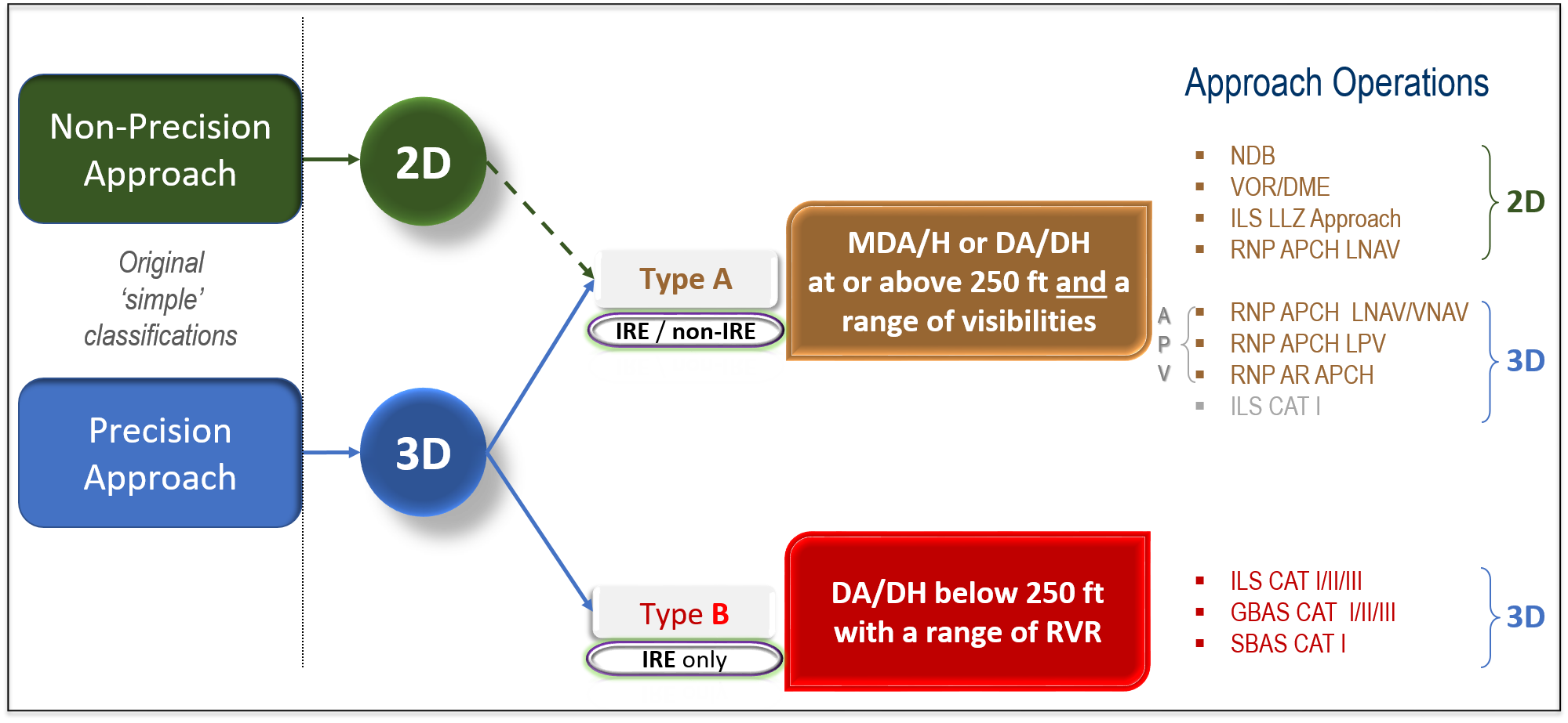
(ntn) The term APV was introduced by ICAO and refers to any RNP approach with a vertical path defined.
The ICAO PBN Manual includes two kinds of approaches. The first is the RNP APCH, the second is the RNP AR APCH. The RNP APCH is the most common and it can be flown by any aircraft. The RNP AR APCH is for exceptional operational circumstances, typically related to terrain rich environments, but more recently, also used for environmental mitigation.
(ntn) RNP AR APCH is very demanding on the flight crew (who require specific operational approval), the level of aircraft certification and avionics. And it is expensive. This is why it tends to be used exceptionally and only on a ‘really needs’ basis. It’s greatest advantage to date is that it has permitted aircraft to gain access into airports that were previously unreachable in poor weather e.g. Innsbruck (Austria), Lhasa (Tibet) and Queenstown (New Zealand).
RNP APCH chart titles usually show RNP RWY {nn}. RNP AR APCH chart titles usually show RNP RWY {nn} (AR). For both kinds of RNP approaches, if there is more than one RNP APCH or RNP AR APCH to the same runway, the letter Y or Z may be inserted between RNP and the acronym RWY in the chart title.
If the chart is entitled RNP Z RWY 23L, then this is typically in the clearance phraseology used by ATC. This follows the same logic as currently used for conventional procedures. What PBN and GLS introduced into the naming convention aside from the new way of executing a GPS-based approach is the inclusion of letter Y or Z after the kind of approach used. This extra letter has ‘migrated’ its use to ILS approaches e.g. if a runway has an ILS Z RWY 24, the Z is an indicator that there is another ‘version’ of the ILS aside from the one marked ILS Z (but the clearance currently authorised is for ILS ‘version’ Z). Y or Z after RNP on a chart title are often seen, and they are the flag to the pilot, which specific ‘version’ of the particular approach path is being authorised.
RNP APCH is the most common PBN approach. It is mandated by the PBN IR (see below). RNP APCH can be published with three different lines of minima:
- LNAV only, which means no vertical path is provided
- LNAV/VNAV (which means that vertical path is defined and positioning on that path is achieved using Barometric altimetry)
- LPV (which means that vertical path is defined and positioning on that path is achieved geometrically using SBAS, (EGNOS in Europe)
An RNP APCH retains the name ‘RNP APCH’ irrespective of which line of minima is published or used. Lines of minima are the responsibility of the pilot.
T and Y refers to the fact that the plan view of the approach resembles the letter T in a T approach with the main stem of the T on the runway centreline, or resembles a Y in the Y approach, with the main stem of the Y on the runway centreline.
The decision for which design to use is up to the State and/or the procedure designer. Terrain will probably be a significant element in whether a T or Y design is employed.
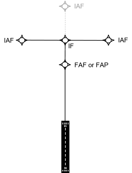
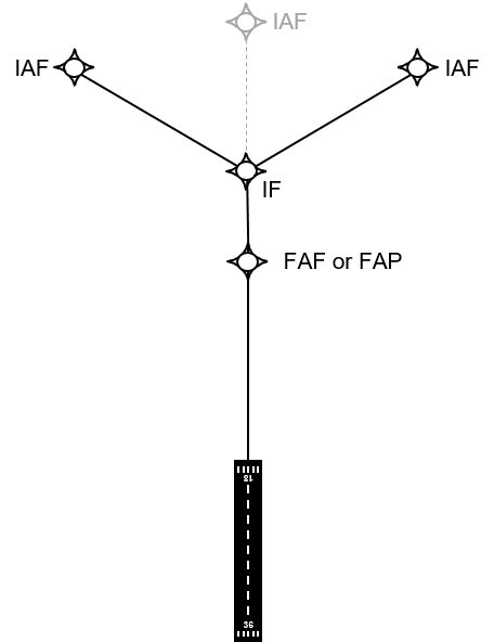
(ntn) A Final Approach Fix (FAF) relates to barometric altimetry and will be used for LNAV and LNAV/VNAV procedures. A Final Approach Point (FAP) relates to geometric altimetry and vertical positioning from the WGS84 ellipsoid. A FAP is published for LPV procedures. There is very little difference in the position of the FAFor FAP waypoint, so only one will be displayed on a chart with all three minima lines.
ALL of the RNP APCH specifications require the use of GPS. This is why when GPS is not available or cannot be used, no RNP approaches are possible at all. If EGNOS is unusable GPS is still usable, then RNP APCH to LNAV and LNAV/VNAV minima is possible, but not LPVs.
The controller cannot know instantly when either GPS or EGNOS is no longer available. The first controllers are likely to hear is pilots stating that they cannot continue the approach. In this case, the aircraft would have to execute a missed approach (sometimes called an extraction or a go-around), unless the pilot can complete a visual approach. The go-around is usually published on the RNP APCH chart so the controller and pilot both know what the aircraft will do.
For decades, PANS-ATM only permitted aircraft to be radar vectored for parallel runway operations. The introduction of RNP approaches has changed that. PANS-ATM accommodates the use of RNP AR APCH for Modes 1 and 2 where the other aircraft is executing either an RNP AR APCH or an ILS or GLS. See N2K – #44.
PBN in the approach phase of flight, specifically RNP APCH, was introduced for safety reasons, to reduce controlled flight into terrain (CFIT), runway excursions, hard landings etc. The PBN IR requires all instrument runways ends (IRE) in EU treaty states to have publish an RNP APCH with three lines of minima by 25th January 2024.