European Free Route Airspace (FRA) is a unique concept that is not the same as other airspace concepts without fixed published ATS Routes. (Other such concepts exist on other continents but have different associated procedures). In the European FRA, independent ATS surveillance is the baseline, area navigation techniques based on PBN (RNAV 5) are required for operation in the airspace, but there is no systemisation and strategic deconfliction of the flight-crew created flight paths and ATC is expected to intervene for conflict resolution. (Note: for the RNAV 5 requirement, see ICAO EUR SUPPS, Doc, 7030).
Given the PBN requirements, Waypoints marking the entry and exit of the European FRA are identified with 5LNC published in the AIP. Manual insertion of waypoints is possible in the FRA.
As there is no published flight path in a FRA, but only one determined by the flight crew, the RNAV 5 requirement means that an aircraft operating on a flight-crew defined flight path has to remain ± 5NM either side of that flight path’s centreline 95% of the flight time.
(ntn) The picture below provides a snapshot of FRA and ATS Routes as regards their use and Publication.
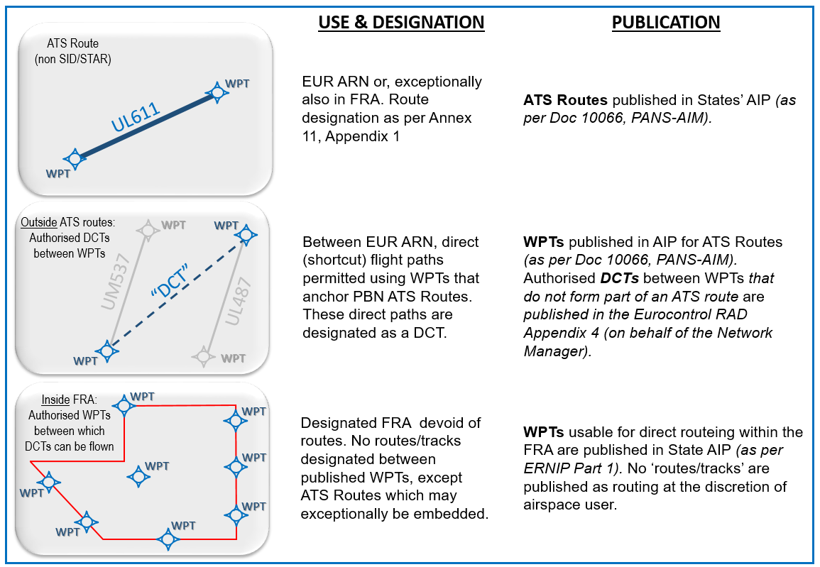
(ntn) Airspace designers will ensure that ATS Routes (which may be SIDs/STARs) are connected to one of the published waypoints marking entry/exit to the FRA. Controllers would expect an aircraft to enter/leave the FRA via a published waypoint.
The PBN IR requirements and the reality that by 2024 all aircraft operating in EU Treaty states will be GPS equipped which means that this will be the primary positioning source used by most commercial air transport aircraft. See N2K – #14.
Given the extensive reliance on GPS in the FRA, GPS becoming unusable would be expected to have a major impact. However, the impact has the potential to be ‘easily’ mitigated because over 95% of Europe’s commercial air transport fleet is DME/DME equipped, and Europe has an extensive DME infrastructure with excellent coverage at altitudes above FL305 (above which FRA has been mandated by December 2022). Essentially, RNAV 5 operations could continue based on DME/DME positioning in the FRA. Nevertheless, a percentage of aircraft which are only GPS equipped would need navigational guidance from ATC.
When GNSS becomes unusable, there may initially be an increase in coordination between affected ATC Units and/or with the unit performing extended sequencing or sequencing function. However, the Unit’s comprehensive Contingency procedures should mitigate excessive workload increase. See N2K – #16.
In the event of GPS being unusable, some of the fixed ATS Routes (in context, more likely to be GPS specific SIDs/STARs), may cease to be available for use. This could affect the points at which transfer of control and communication takes place between ATC sectors. However, the Unit’s Contingency procedures should mitigate excessive workload increase. See N2K – #16.