PBN requires the use of a navigation computer, either integrated into a FMS (Flight Management System) or a GPS with an area navigation system that may not be as extensive as FMS’s, found on commercial transport aircraft. These on-board navigation systems are computers, that have their own computer language and rely on accurate data being inserted into the computer.
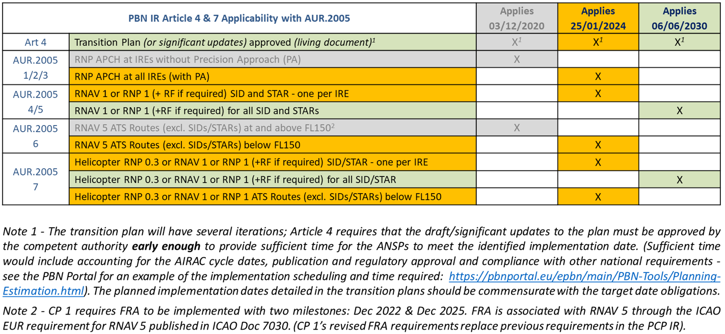
By 2030, PBN will be mandatory in all flight phases. It has been mandatory in the en route since 1998 (see ICAO EUR Doc 7030 for the RNAV 5 requirement); and RNAV 1 as a minimum is now being mandated for SIDs/STARs and RNP APCH for all Instrument Runway Ends (IREs). The PBN roadmap is depicted in the table below:
The PBN IR only requires PBN in all phases of flight and on all procedures in 2030. Until then, a mix of conventional navigation and PBN procedures is permitted. Typically, a mixed environment is more challenging for controllers to handle as controllers need to know an aircraft’s equipage to issue it with a clearance. This means either that the ATC flight plan data from Items 10 and 18 must be available to the controller through the Flight Data Processor or the Surveillance Data Processor and this isn't always possible in ATC systems.
A complex system of codes indicating PBN approval status exists in Chapter 15 of PANS-ATM for inclusion in the ICAO Flight Plan Items 10 and 18. For those codes used in Item 18 after PBN/, the first letter of the two character code points towards the navigation specification, and the number indicates a particular sensor (e.g., B1 stands for RNAV 5 with all permitted sensors). This said, some PBN specifications are not yet catered for by ICAO.
If one reads the provision of this rule with N2K #9: it can be seen that the PBN IR has effectively required European PBN operations to use GPS by 2024. GPS is not explicitly mandated by the PBN IR, but because RNP APCH is mandatory at all instrument runway ends by 2024, this means that from this date every aircraft operating in an EU treaty state will be GPS equipped. As such, each aircraft’s on-board area navigation system will use this GPS as the positioning source of preference. Hence the emphasis on the need for contingency procedures in the event of GPS becoming unusable.
 Important to understand: GPS provides position and timing information. GPS position is the positioning source for ADS-B as well as for navigation applications. GPS timing is used to synchronise surveillance data fusion and provides timing message stamping for CPDLC. Because aviation’s C-N-S technologies all use GPS, it can become a single point of failure. Notably, beyond aviation, GPS is also used by banks, power stations, stock exchanges, drones, warehouses as well as ships, trains and road hauliers, so it potential represents a weak point in digital societies. As such, national strategy plans will probably include GPS as part of the essential infrastructure.
It is obvious that there is an increasing dependence on GPS across the CNS/ATM community. This is why contingency procedures must be developed in a multi-disciplinary way and why controllers must become involved in projects at the ATCUs when these procedures are developed.
In their local operating procedures, every ATCU must include contingency procedures to be used in the event of GPS being unusable. These contingency procedures should cover all flight phases and include inter-sector coordination, inter-Unit coordination, RTF changes if any, and changes to procedures and routeings, as applicable.
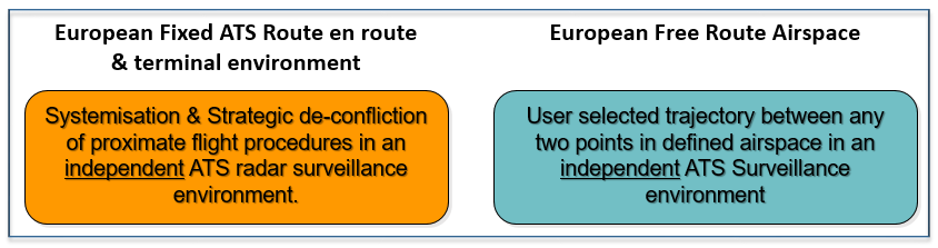
In an environment where PBN ATS routes that are systemised and/or strategically deconflicted, controllers have less radar vectoring and more monitor. In a FRA where the aircraft operator chooses its own trajectory, controllers will be responsible for resolving conflicts tactically; strategic deconfliction is not part of the European Free Route Airspace concept.
Whether the operations pertain to PBN ATS routes that are systemised and/or strategically deconflicted OR there are PBN aircraft operations in Free Route Airspace, controllers’ responsibility for avoidance of collision between aircraft does not change by PBN, but the way in which the functions are exercised may changed.
Significant points or fixes on all PBN routes and on IAPs are marked by Waypoints and they are seldom in the same place as Navaids.
Waypoints are either pronounceable 5-letter name codes (5LNC) or Alpha Numeric (AAnnn). An example of a 5LNC is “TIPTO”. An example of an Alphanumeric waypoint identifier is BR546 where BR represents the last two letters of the ICAO location indicator in this case for Brussels National (EBBR) and the three digits are advised to be above 400 so as to avoid confusion with heading, speed or level restrictions used in terminal operations.
- 5LNC are typically used for FRA and on en route ATS Routes and sometimes on SIDS/STARs.
- Alpha Numeric waypoint identifiers are usually used on IAPs and SIDs/STARs.
Published PBN ATS Routes and SIDs/STARs as well as IAPs must be loaded into the FMS or equivalent to allow the RNAV system to navigate. These procedures can include speed and altitude constraints as part of the route description. When aircraft operate on a route, sophisticated FMS’s are capable of managing the aircraft flight profile, fuel efficiency and the aircraft operations.
PBN’s great flexibility and opportunities to create routes and place them anywhere has shown that it becomes temping to design too many SIDs/STARs which could become a safety hazard… and there is a chance of running out of Waypoint names.
Clearly, PBN has pushed navigation into the digital age, which means there is a great reliance on computers and software. The latter is a great bonus but can be a menace if errors enter the system. Controllers should become part of airspace design initiatives in their units because controllers have a direct interest in where the routes are to be placed because it is the controllers who will have to manage them. Aim for simplicity!